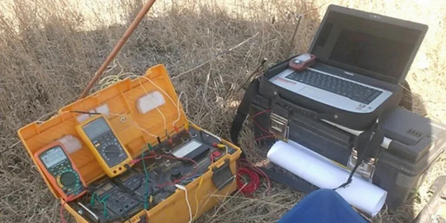
Norfolk builders and civil engineers face a unique underground puzzle. The city sits on the Atlantic Coastal Plain, where the water table is often less than three feet below the surface. IBC Chapter 18 and ASCE 7 require a clear picture of subsurface conditions before foundation design begins. Electrical resistivity surveys, specifically Vertical Electrical Sounding, cut through that saltwater-saturated uncertainty. The method injects a controlled current into the ground and measures how the soil resists it. Sandy strata, clay lenses, and brackish groundwater each return a distinct signature. The result is a layered profile that tells you exactly where bearing soils, fill, or corrosive zones begin and end. For projects near the Lafayette River or the Elizabeth, the data often reveals saline intrusion that standard borings miss entirely. This geophysical approach is fast, non-invasive, and fits the tight urban lots of Ghent and Ocean View without tearing up pavement.
In a city where the groundwater is brackish three feet down, resistivity data does what a backhoe cannot: it sees the salt before you dig into it.
How we work
Local ground factors
Soil conditions shift dramatically between two Norfolk neighborhoods just five miles apart. Ocean View sits on sandy, well-drained ridges where resistivity values run high and foundation corrosion risk stays moderate. Move south toward the industrialized waterfront along the Eastern Branch, and the profile flips. Thick layers of soft organic silt and high-salinity groundwater drop the resistivity to aggressive levels. Concrete piles and steel sheet piling in that zone face a severe corrosion environment if the design ignores the electrical data. The biggest cost trap is assuming uniform soil. A footing designed for sandy loam fails differently than one placed on saturated, low-resistivity marine clay. The survey reveals these transitions before the first yard of concrete is poured, letting the structural engineer specify the right concrete cover, sulfate-resistant cement, or cathodic protection from the start.
Regulatory framework
IBC 2021 Chapter 18 (Soils and Foundations), ASCE 7-22 (Minimum Design Loads for Buildings), ASTM D6431-18 (Standard Guide for Using the DC Resistivity Method)
Related services
Stratigraphic profiling
Vertical Electrical Sounding maps the depth to competent bearing strata, the water table, and the thickness of compressible clay layers across the site.
Soil corrosivity assessment
Low resistivity readings flag zones where buried steel and concrete are at risk. The data guides protective measures for pipelines, ductile iron, and foundation piles.
Groundwater and saline intrusion mapping
The sharp contrast between fresh and brackish water lets the survey trace the saltwater wedge inland, critical for dewatering design and long-term material durability.
Pre-construction geophysical screening
For tight sites, the non-invasive survey identifies anomalies and old fill before the drilling rig arrives, reducing the number of invasive tests required.
Typical parameters
Quick answers
How much does an electrical resistivity survey cost in Norfolk?
For a typical Vertical Electrical Sounding survey in Norfolk, project costs range from US$600 to US$1,090. The final price depends on the number of soundings, the target depth, and site access constraints. A site with dense vegetation or buried utility lines requires more setup time, which is factored into the quote.
How does the high water table in Norfolk affect the resistivity readings?
A shallow water table actually improves data quality. Saturated pores conduct electrical current more efficiently, creating a stronger contrast between sandy and clay-rich units. The survey easily distinguishes clean, water-bearing sand from soft, low-resistivity marine clay. The technical team notes the tidal cycle during data collection to account for minor fluctuations in the saltwater interface.
What depth can a VES survey reach in urban Norfolk?
The maximum investigation depth is roughly one-third of the total electrode spread length. In an open lot, a 300-foot spread can probe down to about 100 feet. Tight urban sites in Ghent or Downtown Norfolk limit the spread, which reduces penetration. In those cases, the team adjusts the array geometry to maximize depth within the available space while still meeting the project's geotechnical objectives. More info.